• Alfred M. Hallmark
  • First Baptist Church of Zephyr
  • Military Road
  • Belle Plaine Cemetery
  • Community of Fodice
  • Providence Church and Cemetery
  • Packsaddle Mountain
  • No. 59 Old San Antonio Road
  • Anderson County in the Civil War
  • Smithfield Baptist Church
  • Phair Cemetery
  • New Page
  • New Page
  • New Page
TEXAS HISTORICAL MARKERS

​Bastrop County

B
A
S
T
R
O
P

C
O
U
N
T
Y
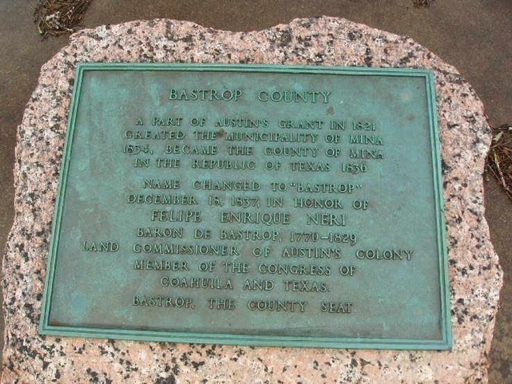
Marker Text: A part of Austin's grant in 1821; created the municipality of Mina, 1834; became the County of Mina in the Republic of Texas, 1836. Name changed to "Bastrop," December 18, 1837, in honor of Felipe Enrique Neri, Baron de Bastrop, 1770-1829, land commissioner of Austin's Colony. Member of the Congress of Coahuila and Texas. Bastrop, the County Seat. (1936) 
Marker No: 9152
Pink Granite 1936 County Centennial Marker
Geographic: 30.110395,-97.293915
Location: intersection of Loop 150 and SH 21 - island between the two roads, near entrance to Bastrop State Park, Bastrop
Picture
Proudly powered by Weebly
  • Alfred M. Hallmark
  • First Baptist Church of Zephyr
  • Military Road
  • Belle Plaine Cemetery
  • Community of Fodice
  • Providence Church and Cemetery
  • Packsaddle Mountain
  • No. 59 Old San Antonio Road
  • Anderson County in the Civil War
  • Smithfield Baptist Church
  • Phair Cemetery
  • New Page
  • New Page
  • New Page