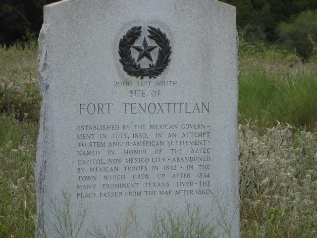
• Alfred M. Hallmark
  • First Baptist Church of Zephyr
  • Military Road
  • Belle Plaine Cemetery
  • Community of Fodice
  • Providence Church and Cemetery
  • Packsaddle Mountain
  • No. 59 Old San Antonio Road
  • Anderson County in the Civil War
  • Smithfield Baptist Church
  • Phair Cemetery
  • New Page
  • New Page
  • New Page
TEXAS HISTORICAL MARKERS

​2000 feet south
site of

Fort Tenoxtitlan

B
U
R
L
E
S
O
​N

C
O
U
N
T
​Y
Marker Text: established by the Mexican government in July, 1830, in an attempt to stem Anglo-American settlement. Named in honor of the Aztec capital, now Mexico City. Abandoned by Mexican troops in 1832. In the town which grew up after 1834 many prominent Texans lived. The place passed from the map after 1860 (1936) 
Marker No: 8633
1936 Gray Granite Centennial 
Geographic: 30.692654,-96.586273
Location: from Caldwell take SH 21 east about 6 miles to FM 1362, go north about 8 miles to CR 338, go east about 1.5 miles to double gate - marker is about 1/2 mile south across creek
Picture
Proudly powered by Weebly
  • Alfred M. Hallmark
  • First Baptist Church of Zephyr
  • Military Road
  • Belle Plaine Cemetery
  • Community of Fodice
  • Providence Church and Cemetery
  • Packsaddle Mountain
  • No. 59 Old San Antonio Road
  • Anderson County in the Civil War
  • Smithfield Baptist Church
  • Phair Cemetery
  • New Page
  • New Page
  • New Page