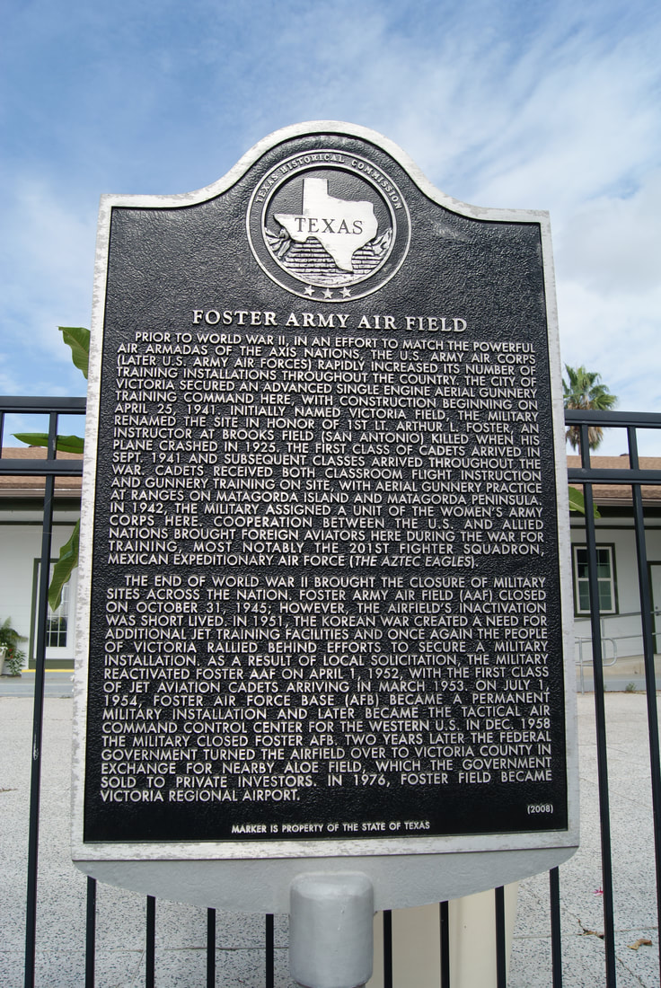
Foster Army Air Field
|
V
I C T O R I A C O U N T Y |
Marker Text: Prior to World War II, in an effort to match the powerful air armadas of the Axis nations, the U.S. Army Air Corps (later U.S. Army Air Forces) rapidly increased its number of training installations throughout the country. The city of Victoria secured an advanced single engine aerial gunnery training command here, with construction beginning on April 25, 1941. Initially named Victoria Field, the military renamed the site in honor of 1st Lt. Arthur L. Foster, an instructor at Brooks Field (San Antonio) killed when his plane crashed in 1925. The first class of cadets arrived in Sept. 1941 and subsequent classes arrived throughout the war. Cadets received both classroom flight instruction and gunnery training on site, with aerial gunnery practice at ranges on Matagorda Island and Matagorda Peninsula. In 1942, the military assigned a unit of the Women's Army Corps here. Cooperation between the U.S. and Allied nations brought foreign aviators here during the war for training, most notably the 201st Fighter Squadron, Mexican Expeditionary Air Force (The Aztec Eagles).
The end of World War II brought the closure of military sites across the nation. Foster Army Air Field (AFF) closed on October 31, 1945; however, the airfield's inactivation was short lived. In 1951, the Korean War created a need for additional jet training facilities and once again the people of Victoria rallied behind efforts to secure a military installation. As a result of local solicitation, the military reactivated Foster AFF on April 1, 1952, with the first class of jet aviation cadets arriving in March 1953. On July 1, 1954, Foster Air Force Base (AFB) became a permanent military installation and later became the tactical air command control center for the western U.S. In Dec. 1958 the military closed Foster AFB. Two years later the federal government turned the airfield over to Victoria County in exchange for nearby Aloe Field, which the government sold to private investors. In 1976, Foster Field became Victoria Regional Airport. (2008) |
Marker No: 14652
Aluminum 27 x 42 Subject Marker
Geographic:28.847717, -96.924240
Location: 333 Bachelor Drive, Victoria
|