• Alfred M. Hallmark
  • First Baptist Church of Zephyr
  • Military Road
  • Belle Plaine Cemetery
  • Community of Fodice
  • Providence Church and Cemetery
  • Packsaddle Mountain
  • No. 59 Old San Antonio Road
  • Anderson County in the Civil War
  • Smithfield Baptist Church
  • Phair Cemetery
  • New Page
  • New Page
  • New Page
TEXAS HISTORICAL MARKERS

Milam County

​M
I
L
A
M

C
O
U
N
T
​Y
Picture
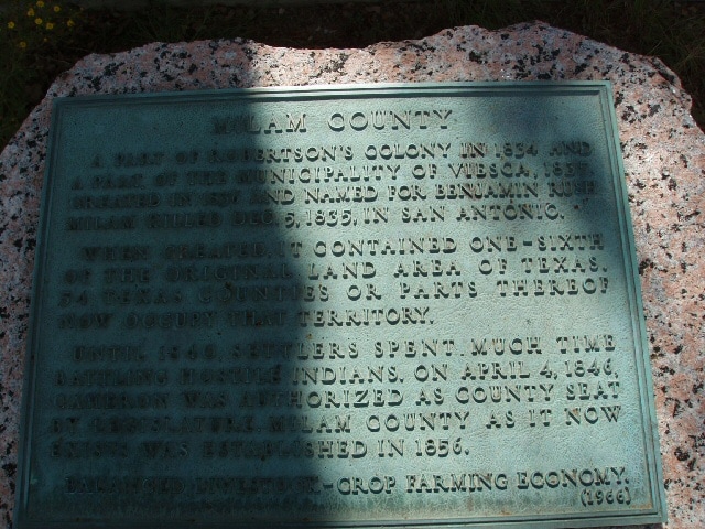
Marker Text: A part of Robertson's colony in 1834. A part of the municipality of Viesca, 1835. Named changed to Milam, December 27, 1835 in honor of Benjamin Rush Milam, 1788-1835, who fell at San Antonio. After Burleson and Robertson counties were cut off Nashville became the county seat in 1837. The later creation of Williamson, Bell, McLennan and Falls, reduced Milam County to its present size. Cameron, the county seat since 1846. (1936 (1966) 
Marker No: 7985
Pink Granite 1936 Centennial County Marker 
Geographic: 30.879065,-96.9771
Location: on US 77 across from Cameron Municipal Airpark in front of Cameron Oaks Apartments, .8 miles from Cameron
Proudly powered by Weebly
  • Alfred M. Hallmark
  • First Baptist Church of Zephyr
  • Military Road
  • Belle Plaine Cemetery
  • Community of Fodice
  • Providence Church and Cemetery
  • Packsaddle Mountain
  • No. 59 Old San Antonio Road
  • Anderson County in the Civil War
  • Smithfield Baptist Church
  • Phair Cemetery
  • New Page
  • New Page
  • New Page