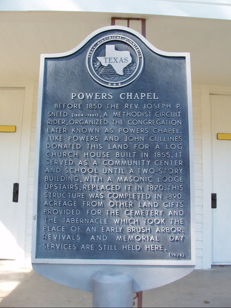
• Texas Historical Markers
  • Greenbrier Cemetery
  • Wilson Chapel Methodist Church
  • Marian Anderson High School
  • Alfred M. Hallmark
  • Frank Mulder Gossett
  • No 57: Old San Antonio Road
  • Zephyr Cemetery
  • Zephyr Gospel Tabernacle
  • First Baptist Church of Zephyr
  • Military Road
  • Zephyr Presbyterian Church
  • Burkett Pecan Tree
  • Hittson Ranch
  • Callahan City Cemetery
  • Admiral Baptist Church
  • Belle Plaine Cemetery
  • Ross Cemetery
  • Callahan County
  • The Prew House
  • Brooke Smith
  • Minnie Fisher Cunningham
  • Ebenezer Baptist Church
  • Dodge
  • Site of Andrew Female College
  • Glendale Cemetery
  • Community of Fodice
  • Holy Rosary Catholic Parish
  • Pegleg Crossing on the San Saba
  • B. T. Brown House
  • German Methodist Church/First Fire Station
  • Providence Church and Cemetery
  • Packsaddle Mountain
  • Homesite of W. F. Heller, Pioneer Farmer
  • The Bosque-Larios Expedition
  • No. 60 Old San Antonio Road
  • No. 56 Old San Antonio Road
  • No. 59 Old San Antonio Road
  • Texas Central Railroad
  • Center City Community
  • Orla
  • Fairview Cemetery
  • Leon County Courthouse
  • Anderson County in the Civil War
  • Judge H.T. Brown
  • Washington County, C.S.A.
  • Leander
  • Oveta Culp Hobby and the Women's Army Corps
  • Jacob Haller House
  • James M. Holt
  • Washington-on-the Brazos
  • Donigan House
  • Fort Worth Stock Yards Entrance
  • Smithfield Baptist Church
  • Elite Cafe
  • Joseph Brooks Home
  • Phair Cemetery
  • Robert Justus Kleberg
  • New Page
  • New Page
  • New Page
TEXAS HISTORICAL MARKERS

​Powers Chapel

F
A
L
L
S

C
O
U
N
T
​Y
Picture
Marker Text: ​Before 1850 the Rev. Joseph P. Sneed (1804-1881), a Methodist circuit rider. Organized the congregation later known as Powers Chapel. Luke Powers and John Cullines donated this land for a log church house built in 1855. It served as a community center and school until a two-story building, with a masonic lodge upstairs, replaced it in 1870. This structure was completed in 1890, acreage from other land gifts provided for the cemetery and the tabernacle which took the place of an early brush arbor. Revivals and Memorial Day services are still held here. (1978) 
Marker No: 4103
Aluminum 18 x 28 Subject Marker
Geographic: 31.116390, -96.891739
Location: From Rosebud, take FM 1048 east about 6.1 miles, then go south on Fm 2027 about 1.5 miles
Proudly powered by Weebly
  • Texas Historical Markers
  • Greenbrier Cemetery
  • Wilson Chapel Methodist Church
  • Marian Anderson High School
  • Alfred M. Hallmark
  • Frank Mulder Gossett
  • No 57: Old San Antonio Road
  • Zephyr Cemetery
  • Zephyr Gospel Tabernacle
  • First Baptist Church of Zephyr
  • Military Road
  • Zephyr Presbyterian Church
  • Burkett Pecan Tree
  • Hittson Ranch
  • Callahan City Cemetery
  • Admiral Baptist Church
  • Belle Plaine Cemetery
  • Ross Cemetery
  • Callahan County
  • The Prew House
  • Brooke Smith
  • Minnie Fisher Cunningham
  • Ebenezer Baptist Church
  • Dodge
  • Site of Andrew Female College
  • Glendale Cemetery
  • Community of Fodice
  • Holy Rosary Catholic Parish
  • Pegleg Crossing on the San Saba
  • B. T. Brown House
  • German Methodist Church/First Fire Station
  • Providence Church and Cemetery
  • Packsaddle Mountain
  • Homesite of W. F. Heller, Pioneer Farmer
  • The Bosque-Larios Expedition
  • No. 60 Old San Antonio Road
  • No. 56 Old San Antonio Road
  • No. 59 Old San Antonio Road
  • Texas Central Railroad
  • Center City Community
  • Orla
  • Fairview Cemetery
  • Leon County Courthouse
  • Anderson County in the Civil War
  • Judge H.T. Brown
  • Washington County, C.S.A.
  • Leander
  • Oveta Culp Hobby and the Women's Army Corps
  • Jacob Haller House
  • James M. Holt
  • Washington-on-the Brazos
  • Donigan House
  • Fort Worth Stock Yards Entrance
  • Smithfield Baptist Church
  • Elite Cafe
  • Joseph Brooks Home
  • Phair Cemetery
  • Robert Justus Kleberg
  • New Page
  • New Page
  • New Page