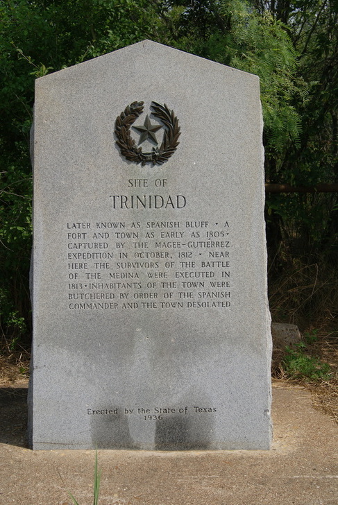
• Texas Historical Markers
  • Taylor County (Master)
  • Greenbrier Cemetery
  • Wilson Chapel Methodist Church
  • Shiloh Missionary Baptist Church
  • Marian Anderson High School
  • Alfred M. Hallmark
  • Frank Mulder Gossett
  • No 57: Old San Antonio Road
  • Zephyr Cemetery
  • Zephyr Gospel Tabernacle
  • First Baptist Church of Zephyr
  • Military Road
  • Zephyr Presbyterian Church
  • Burkett Pecan Tree
  • Hittson Ranch
  • Callahan City Cemetery
  • Admiral Baptist Church
  • Belle Plaine Cemetery
  • Ross Cemetery
  • Callahan County
  • The Prew House
  • Brooke Smith
  • Minnie Fisher Cunningham
  • Ebenezer Baptist Church
  • Temple Beth El
  • Dodge
  • Site of Andrew Female College
  • Glendale Cemetery
  • Community of Fodice
  • Holy Rosary Catholic Parish
  • Pegleg Crossing on the San Saba
  • B. T. Brown House
  • German Methodist Church/First Fire Station
  • Providence Church and Cemetery
  • Packsaddle Mountain
  • Homesite of W. F. Heller, Pioneer Farmer
  • The Bosque-Larios Expedition
  • No. 60 Old San Antonio Road
  • No. 56 Old San Antonio Road
  • No. 59 Old San Antonio Road
  • Texas Central Railroad
  • Center City Community
  • Orla
  • Fairview Cemetery
  • Leon County Courthouse
  • Anderson County in the Civil War
  • Judge H.T. Brown
  • Washington County, C.S.A.
  • Leander
  • Oveta Culp Hobby and the Women's Army Corps
  • Jacob Haller House
  • James M. Holt
  • Washington-on-the Brazos
  • Donigan House
  • Fort Worth Stock Yards Entrance
  • Smithfield Baptist Church
  • Elite Cafe
  • Joseph Brooks Home
  • New Page
  • New Page
  • New Page
  • New Page
  • New Page
  • New Page
Texas Historical Markers

Madison County

Site of Trinidad

Picture
Later known as Spanish Bluff. A fort and town as early as 1805. Captured by the Magee-Gutierrez Expedition in October, 1812. Near here the survivors of the Battle of the Medina were executed in 1813. Inhabitants of the town were butchered by order of the Spanish commander and the town desolated. (1936) 
Marker No. 11263
 1936 Gray Granite Centennial Marker 
Geographic: 31.068403, -95.709007
Location: from Midway, take SH 21 about 3.5 miles east to marker on south side of road
Proudly powered by Weebly
  • Texas Historical Markers
  • Taylor County (Master)
  • Greenbrier Cemetery
  • Wilson Chapel Methodist Church
  • Shiloh Missionary Baptist Church
  • Marian Anderson High School
  • Alfred M. Hallmark
  • Frank Mulder Gossett
  • No 57: Old San Antonio Road
  • Zephyr Cemetery
  • Zephyr Gospel Tabernacle
  • First Baptist Church of Zephyr
  • Military Road
  • Zephyr Presbyterian Church
  • Burkett Pecan Tree
  • Hittson Ranch
  • Callahan City Cemetery
  • Admiral Baptist Church
  • Belle Plaine Cemetery
  • Ross Cemetery
  • Callahan County
  • The Prew House
  • Brooke Smith
  • Minnie Fisher Cunningham
  • Ebenezer Baptist Church
  • Temple Beth El
  • Dodge
  • Site of Andrew Female College
  • Glendale Cemetery
  • Community of Fodice
  • Holy Rosary Catholic Parish
  • Pegleg Crossing on the San Saba
  • B. T. Brown House
  • German Methodist Church/First Fire Station
  • Providence Church and Cemetery
  • Packsaddle Mountain
  • Homesite of W. F. Heller, Pioneer Farmer
  • The Bosque-Larios Expedition
  • No. 60 Old San Antonio Road
  • No. 56 Old San Antonio Road
  • No. 59 Old San Antonio Road
  • Texas Central Railroad
  • Center City Community
  • Orla
  • Fairview Cemetery
  • Leon County Courthouse
  • Anderson County in the Civil War
  • Judge H.T. Brown
  • Washington County, C.S.A.
  • Leander
  • Oveta Culp Hobby and the Women's Army Corps
  • Jacob Haller House
  • James M. Holt
  • Washington-on-the Brazos
  • Donigan House
  • Fort Worth Stock Yards Entrance
  • Smithfield Baptist Church
  • Elite Cafe
  • Joseph Brooks Home
  • New Page
  • New Page
  • New Page
  • New Page
  • New Page
  • New Page