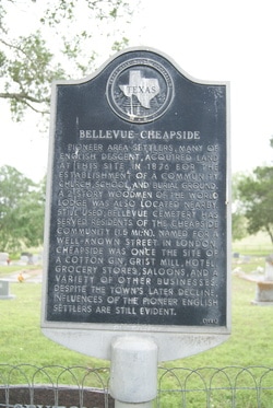
Bellevue-Cheapside
|
D
E W I T T C O U N T Y |
Marker Text: Pioneer area settlers, many of English descent, acquired land at this site in 1876 for the establishment of a community church, school, and burial ground. A 2-story Woodmen of the World Lodge was also located nearby. Still used, Bellevue Cemetery has served residents of the Cheapside community (1.5 miles north). Named for a well-known street in London, Cheapside was once the site of a cotton gin, grist mill, hotel, grocery stores, saloons, and a variety of other businesses. Despite the town's later decline, influences of the pioneer English settlers are still evident. (1981)
Marker No: 362
Aluminum 18 x 28 Subject Marker
|
Geographic: 29.250175,-97.405258
Location: from Cuero, take FM 766 northwest about 7 miles then go 5.5 miles north west on CR to Bellevue Cheapside Cemetery
|