• Texas Historical Markers
  • Greenbrier Cemetery
  • Wilson Chapel Methodist Church
  • Marian Anderson High School
  • Alfred M. Hallmark
  • Frank Mulder Gossett
  • No 57: Old San Antonio Road
  • Zephyr Cemetery
  • Zephyr Gospel Tabernacle
  • First Baptist Church of Zephyr
  • Military Road
  • Zephyr Presbyterian Church
  • Burkett Pecan Tree
  • Hittson Ranch
  • Callahan City Cemetery
  • Admiral Baptist Church
  • Belle Plaine Cemetery
  • Ross Cemetery
  • Callahan County
  • The Prew House
  • Brooke Smith
  • Minnie Fisher Cunningham
  • Ebenezer Baptist Church
  • Dodge
  • Site of Andrew Female College
  • Glendale Cemetery
  • Community of Fodice
  • Holy Rosary Catholic Parish
  • Pegleg Crossing on the San Saba
  • B. T. Brown House
  • German Methodist Church/First Fire Station
  • Providence Church and Cemetery
  • Packsaddle Mountain
  • Homesite of W. F. Heller, Pioneer Farmer
  • The Bosque-Larios Expedition
  • No. 60 Old San Antonio Road
  • No. 56 Old San Antonio Road
  • No. 59 Old San Antonio Road
  • Texas Central Railroad
  • Center City Community
  • Orla
  • Fairview Cemetery
  • Leon County Courthouse
  • Anderson County in the Civil War
  • Judge H.T. Brown
  • Washington County, C.S.A.
  • Leander
  • Oveta Culp Hobby and the Women's Army Corps
  • Jacob Haller House
  • James M. Holt
  • Washington-on-the Brazos
  • Donigan House
  • Fort Worth Stock Yards Entrance
  • Smithfield Baptist Church
  • Elite Cafe
  • Joseph Brooks Home
  • Phair Cemetery
  • Robert Justus Kleberg
  • New Page
  • New Page
TEXAS HISTORICAL MARKERS

Callahan County

C
A
L
L
A
H
A
N

C
O
U
N
T
Y
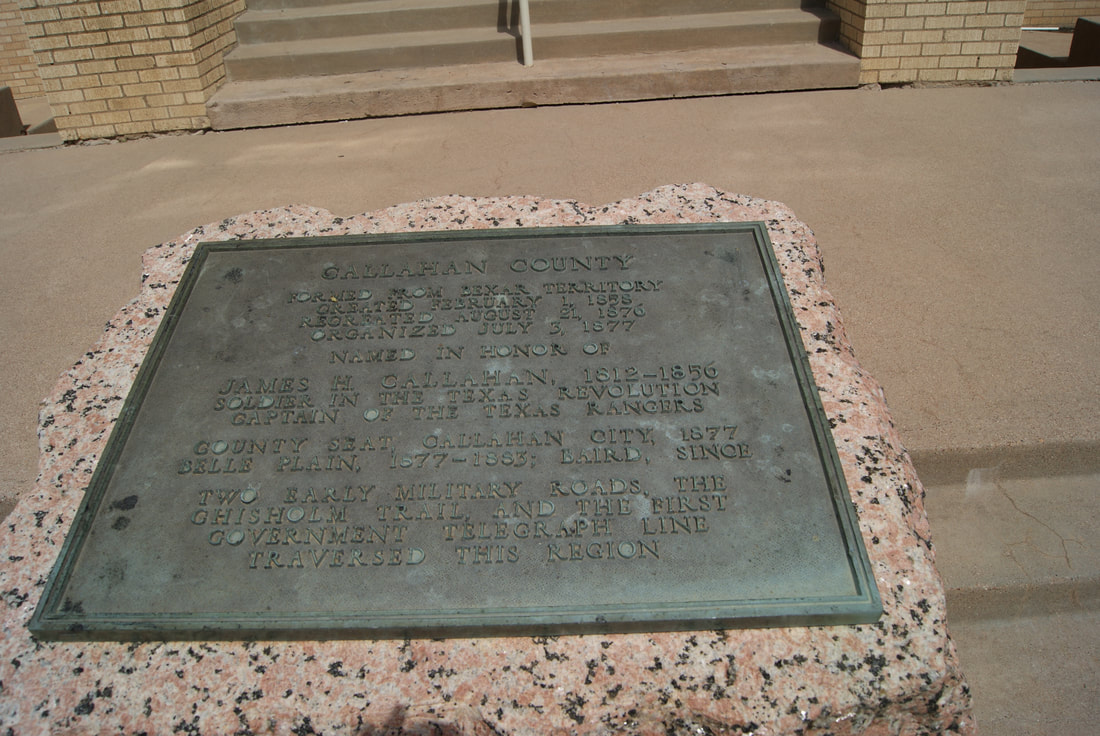
Marker Text: Formed from Bexar Territory, created February 1, 1858; recreated August 21, 1876; organized July 3, 1877.
   Named in Honor of James H. Callahan, 1812-1856 soldier in the Texas Revolution, captain of the Texas Rangers.
​   County Seat, Callahan City, 1877; Belle Plain, 1877-1883; Baird, since two early military roads, the Chisholm Trail, and the first government telegraph line traversed this region. (1936)
Marker No: 634
1936 Pink Granite Centennial Highway Marker
Geographic:32.394661, -99.395264
Location:  front lawn of Courthouse, Baird; on US 20 Business
Picture
Proudly powered by Weebly
  • Texas Historical Markers
  • Greenbrier Cemetery
  • Wilson Chapel Methodist Church
  • Marian Anderson High School
  • Alfred M. Hallmark
  • Frank Mulder Gossett
  • No 57: Old San Antonio Road
  • Zephyr Cemetery
  • Zephyr Gospel Tabernacle
  • First Baptist Church of Zephyr
  • Military Road
  • Zephyr Presbyterian Church
  • Burkett Pecan Tree
  • Hittson Ranch
  • Callahan City Cemetery
  • Admiral Baptist Church
  • Belle Plaine Cemetery
  • Ross Cemetery
  • Callahan County
  • The Prew House
  • Brooke Smith
  • Minnie Fisher Cunningham
  • Ebenezer Baptist Church
  • Dodge
  • Site of Andrew Female College
  • Glendale Cemetery
  • Community of Fodice
  • Holy Rosary Catholic Parish
  • Pegleg Crossing on the San Saba
  • B. T. Brown House
  • German Methodist Church/First Fire Station
  • Providence Church and Cemetery
  • Packsaddle Mountain
  • Homesite of W. F. Heller, Pioneer Farmer
  • The Bosque-Larios Expedition
  • No. 60 Old San Antonio Road
  • No. 56 Old San Antonio Road
  • No. 59 Old San Antonio Road
  • Texas Central Railroad
  • Center City Community
  • Orla
  • Fairview Cemetery
  • Leon County Courthouse
  • Anderson County in the Civil War
  • Judge H.T. Brown
  • Washington County, C.S.A.
  • Leander
  • Oveta Culp Hobby and the Women's Army Corps
  • Jacob Haller House
  • James M. Holt
  • Washington-on-the Brazos
  • Donigan House
  • Fort Worth Stock Yards Entrance
  • Smithfield Baptist Church
  • Elite Cafe
  • Joseph Brooks Home
  • Phair Cemetery
  • Robert Justus Kleberg
  • New Page
  • New Page