• Greenbrier Cemetery
  • Wilson Chapel Methodist Church
  • Marian Anderson High School
  • Alfred M. Hallmark
  • No 57: Old San Antonio Road
  • Zephyr Cemetery
  • Zephyr Gospel Tabernacle
  • First Baptist Church of Zephyr
  • Military Road
  • Zephyr Presbyterian Church
  • Burkett Pecan Tree
  • Hittson Ranch
  • Callahan City Cemetery
  • Admiral Baptist Church
  • Belle Plaine Cemetery
  • Ross Cemetery
  • The Prew House
  • Brooke Smith
  • Minnie Fisher Cunningham
  • Ebenezer Baptist Church
  • Dodge
  • Site of Andrew Female College
  • Glendale Cemetery
  • Community of Fodice
  • Pegleg Crossing on the San Saba
  • B. T. Brown House
  • German Methodist Church/First Fire Station
  • Providence Church and Cemetery
  • Packsaddle Mountain
  • Homesite of W. F. Heller, Pioneer Farmer
  • The Bosque-Larios Expedition
  • No. 60 Old San Antonio Road
  • No. 56 Old San Antonio Road
  • No. 59 Old San Antonio Road
  • Texas Central Railroad
  • Center City Community
  • Orla
  • Fairview Cemetery
  • Anderson County in the Civil War
  • Leander
  • Oveta Culp Hobby and the Women's Army Corps
  • Jacob Haller House
  • James M. Holt
  • Washington-on-the Brazos
  • Donigan House
  • Fort Worth Stock Yards Entrance
  • Smithfield Baptist Church
  • Elite Cafe
  • Joseph Brooks Home
  • Phair Cemetery
  • Witting School
  • Pioneer Bank Building
  • Whitney Memorial Park
  • Site of Alvarado School, Church and Union Building
  • Two Sheriffs of Mason County
  • New Page
  • New Page
  • New Page
  • New Page
  • New Page
  • New Page
  • New Page
  • New Page
TEXAS HISTORICAL MARKERS

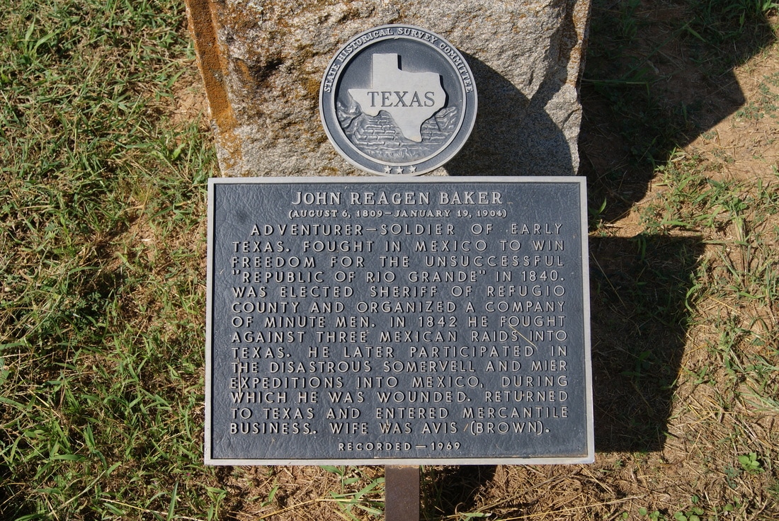
​John Reagan Baker (August 6, 1809 - January 19, 1904) 

W
I
L
S
O
N

C
O
U
N
T
​Y
Marker Text : Adventurer-soldier of early Texas. Fought in Mexico to win freedom for the unsuccessful "Republic of Rio Grande" in 1840. Was elected sheriff of Refugio County and organized a company of minutemen. In 1842 he fought against three Mexican raids into Texas. Then participated in the disastrous Somervell and Mier expeditions into Mexico, during which he was wounded. Returned to Texas and entered mercantile business. Wife was Avis (Brown). (1969) 
Picture
Marker No: 2804
Grave Marker
Geographic: 29.230476, - 97.969284
Location: In Stockdale Cemetery, US 87 Bypass, Stockdale. Take main entrance to cemetery, drive to the right of the flagpole. Marker and grave located south of curve.
Proudly powered by Weebly
  • Greenbrier Cemetery
  • Wilson Chapel Methodist Church
  • Marian Anderson High School
  • Alfred M. Hallmark
  • No 57: Old San Antonio Road
  • Zephyr Cemetery
  • Zephyr Gospel Tabernacle
  • First Baptist Church of Zephyr
  • Military Road
  • Zephyr Presbyterian Church
  • Burkett Pecan Tree
  • Hittson Ranch
  • Callahan City Cemetery
  • Admiral Baptist Church
  • Belle Plaine Cemetery
  • Ross Cemetery
  • The Prew House
  • Brooke Smith
  • Minnie Fisher Cunningham
  • Ebenezer Baptist Church
  • Dodge
  • Site of Andrew Female College
  • Glendale Cemetery
  • Community of Fodice
  • Pegleg Crossing on the San Saba
  • B. T. Brown House
  • German Methodist Church/First Fire Station
  • Providence Church and Cemetery
  • Packsaddle Mountain
  • Homesite of W. F. Heller, Pioneer Farmer
  • The Bosque-Larios Expedition
  • No. 60 Old San Antonio Road
  • No. 56 Old San Antonio Road
  • No. 59 Old San Antonio Road
  • Texas Central Railroad
  • Center City Community
  • Orla
  • Fairview Cemetery
  • Anderson County in the Civil War
  • Leander
  • Oveta Culp Hobby and the Women's Army Corps
  • Jacob Haller House
  • James M. Holt
  • Washington-on-the Brazos
  • Donigan House
  • Fort Worth Stock Yards Entrance
  • Smithfield Baptist Church
  • Elite Cafe
  • Joseph Brooks Home
  • Phair Cemetery
  • Witting School
  • Pioneer Bank Building
  • Whitney Memorial Park
  • Site of Alvarado School, Church and Union Building
  • Two Sheriffs of Mason County
  • New Page
  • New Page
  • New Page
  • New Page
  • New Page
  • New Page
  • New Page
  • New Page