Jourdanton Independent
School District
|
A
T A S C O S A C O U N T Y |
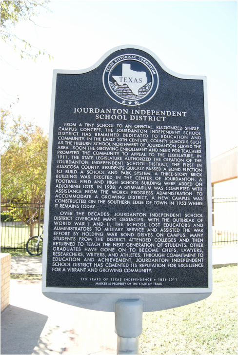
Marker Text: Jourdanton Independent School District from a tiny school to an official, recognized single-campus concept, the Jourdanton Independent School District has remained dedicated to education and community. In the early 20th century, county schools such as the Hilburn School northwest of Jourdanton served the area. Soon the growing enrollment and need for teachers prompted the community to appeal to the legislature. In 1911, the state legislature authorized the creation of the Jourdanton Independent School District, the first in Atascosa County. Residents quickly passed a bond election to build a school and park system. A three-story brick building was erected in the center of Jourdanton. a football field and high school building were added on adjoining lots. In 1938, a gymnasium was completed with assistance from the works progress administration. To accommodate a growing district, a new campus was constructed on the southern edge of town in 1953 where it remains today.
Over the decades, Jourdanton Independent School District overcame many obstacles. with the outbreak of World War I and II, the school lost educators and administrators to military service and assisted the war effort by holding war bond drives on campus. Many students from the district attended colleges and then returned to teach the next generation of students. Other graduates have gone on to become chefs, lawyers, researchers, writers, and athletes. Through commitment to education and achievement, Jourdanton independent school district has cemented its reputation for excellence for a vibrant and growing community. (2011) |
Marker No: 17017
Aluminum 27 x 42 Subject Marker
Geographic: 28° 54.604′ N, 98° 32.465′ W
Location: 200 Zanderson Avenue, Jordanton
|