• Greenbrier Cemetery
  • Wilson Chapel Methodist Church
  • Marian Anderson High School
  • Alfred M. Hallmark
  • Frank Mulder Gossett
  • No 57: Old San Antonio Road
  • Zephyr Cemetery
  • Zephyr Gospel Tabernacle
  • First Baptist Church of Zephyr
  • Military Road
  • Zephyr Presbyterian Church
  • Burkett Pecan Tree
  • Hittson Ranch
  • Callahan City Cemetery
  • Admiral Baptist Church
  • Belle Plaine Cemetery
  • Ross Cemetery
  • Callahan County
  • The Prew House
  • Brooke Smith
  • Minnie Fisher Cunningham
  • Ebenezer Baptist Church
  • Dodge
  • Site of Andrew Female College
  • Glendale Cemetery
  • Community of Fodice
  • Pegleg Crossing on the San Saba
  • B. T. Brown House
  • German Methodist Church/First Fire Station
  • Providence Church and Cemetery
  • Packsaddle Mountain
  • Homesite of W. F. Heller, Pioneer Farmer
  • The Bosque-Larios Expedition
  • No. 60 Old San Antonio Road
  • No. 56 Old San Antonio Road
  • No. 59 Old San Antonio Road
  • Texas Central Railroad
  • Center City Community
  • Orla
  • Fairview Cemetery
  • Leon County Courthouse
  • Anderson County in the Civil War
  • Judge H.T. Brown
  • Washington County, C.S.A.
  • Leander
  • Oveta Culp Hobby and the Women's Army Corps
  • Jacob Haller House
  • James M. Holt
  • Washington-on-the Brazos
  • Donigan House
  • Fort Worth Stock Yards Entrance
  • Smithfield Baptist Church
  • Elite Cafe
  • Joseph Brooks Home
  • Phair Cemetery
  • Robert Justus Kleberg
  • Witting School
  • Pioneer Bank Building
  • Whitney Memorial Park
  • Site of Alvarado School, Church and Union Building
  • New Page
TEXAS HISTORICAL MARKERS

​Natural Bridge Caverns

​C
O
M
A
L

C
O
U
N
T
​Y
Marker Text: ​ Discovered March 27, 1960, by four students of St. Mary's University, San Antonio. Named for the rock bridge that marks entrance. Dedicated on August 5, 1964 by Governor John Connally.
       Of early cretaceous age; still forming. Site of artifacts from 5,00 B.C. and human remains at least 8,000 years old; also Indian campsites. (1967)
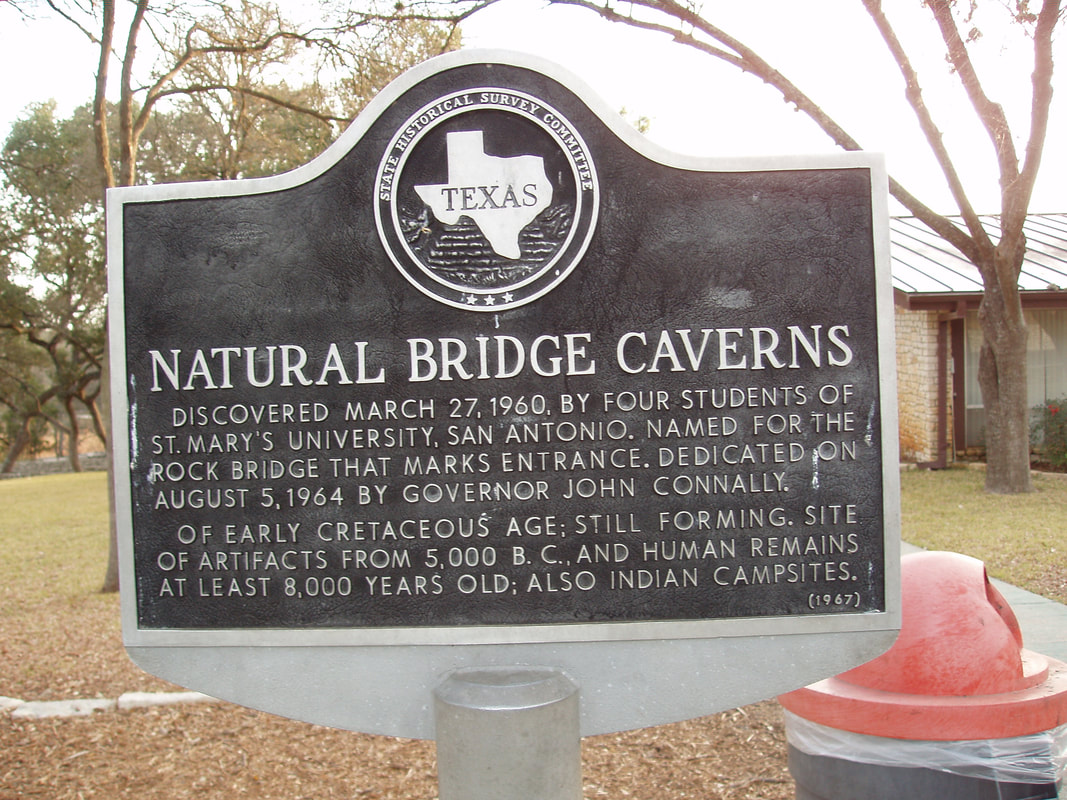
Picture
Marker No: 3552
Aluminum 20 x 20 Subject Marker
National Register of Historic Places
Geographic: 29.692522,-98.342239
Location: from New Braunfels about 8.5 miles west, caverns located on FM 1863
Proudly powered by Weebly
  • Greenbrier Cemetery
  • Wilson Chapel Methodist Church
  • Marian Anderson High School
  • Alfred M. Hallmark
  • Frank Mulder Gossett
  • No 57: Old San Antonio Road
  • Zephyr Cemetery
  • Zephyr Gospel Tabernacle
  • First Baptist Church of Zephyr
  • Military Road
  • Zephyr Presbyterian Church
  • Burkett Pecan Tree
  • Hittson Ranch
  • Callahan City Cemetery
  • Admiral Baptist Church
  • Belle Plaine Cemetery
  • Ross Cemetery
  • Callahan County
  • The Prew House
  • Brooke Smith
  • Minnie Fisher Cunningham
  • Ebenezer Baptist Church
  • Dodge
  • Site of Andrew Female College
  • Glendale Cemetery
  • Community of Fodice
  • Pegleg Crossing on the San Saba
  • B. T. Brown House
  • German Methodist Church/First Fire Station
  • Providence Church and Cemetery
  • Packsaddle Mountain
  • Homesite of W. F. Heller, Pioneer Farmer
  • The Bosque-Larios Expedition
  • No. 60 Old San Antonio Road
  • No. 56 Old San Antonio Road
  • No. 59 Old San Antonio Road
  • Texas Central Railroad
  • Center City Community
  • Orla
  • Fairview Cemetery
  • Leon County Courthouse
  • Anderson County in the Civil War
  • Judge H.T. Brown
  • Washington County, C.S.A.
  • Leander
  • Oveta Culp Hobby and the Women's Army Corps
  • Jacob Haller House
  • James M. Holt
  • Washington-on-the Brazos
  • Donigan House
  • Fort Worth Stock Yards Entrance
  • Smithfield Baptist Church
  • Elite Cafe
  • Joseph Brooks Home
  • Phair Cemetery
  • Robert Justus Kleberg
  • Witting School
  • Pioneer Bank Building
  • Whitney Memorial Park
  • Site of Alvarado School, Church and Union Building
  • New Page