• Alfred M. Hallmark
  • First Baptist Church of Zephyr
  • Military Road
  • Belle Plaine Cemetery
  • Community of Fodice
  • Providence Church and Cemetery
  • Packsaddle Mountain
  • No. 59 Old San Antonio Road
  • Anderson County in the Civil War
  • Smithfield Baptist Church
  • Phair Cemetery
  • New Page
  • New Page
  • New Page
TEXAS HISTORICAL MARKERS

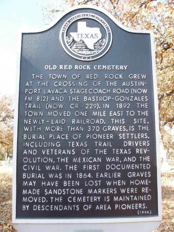
​Old Red Rock Cemetery

B
A
S
T
R
O
P

C
O
U
N
T
Y
​
Picture
Marker No: 9221
Aluminum 18 x 28 Subject Marker
Geographic: 29.963501,-97.428764
Marker Text: ​The town of Red Rock grew at the crossing of the Austin-Port Lavaca Stagecoach Road (now FM 812) and the Bastrop-Gonzales trail (now Cr 229). In 1892 the town moved one mile east to the newly-laid railroad. This site, with more than 370 graves, is the burial place of pioneer settlers, including Texas trail drivers and veterans of the Texas Revolution, the Mexican War, and the Civil War. The first documented burial was in 1864. Earlier graves may been lost when homemade sandstone markers were removed. The cemetery is maintained by descendants of area pioneers. (1996)
Location: ​1 mile west of Red Rock on FM 812, .3 mile south on CR 2291 mile west of Red Rock on FM 812, .3 mile south on CR 2291 mile west of Red Rock on FM 812, .3 mile south on CR 229
Proudly powered by Weebly
  • Alfred M. Hallmark
  • First Baptist Church of Zephyr
  • Military Road
  • Belle Plaine Cemetery
  • Community of Fodice
  • Providence Church and Cemetery
  • Packsaddle Mountain
  • No. 59 Old San Antonio Road
  • Anderson County in the Civil War
  • Smithfield Baptist Church
  • Phair Cemetery
  • New Page
  • New Page
  • New Page