• Greenbrier Cemetery
  • Wilson Chapel Methodist Church
  • Marian Anderson High School
  • Alfred M. Hallmark
  • No 57: Old San Antonio Road
  • Zephyr Cemetery
  • Zephyr Gospel Tabernacle
  • First Baptist Church of Zephyr
  • Military Road
  • Zephyr Presbyterian Church
  • Burkett Pecan Tree
  • Hittson Ranch
  • Callahan City Cemetery
  • Admiral Baptist Church
  • Belle Plaine Cemetery
  • Ross Cemetery
  • The Prew House
  • Brooke Smith
  • Minnie Fisher Cunningham
  • Ebenezer Baptist Church
  • Dodge
  • Site of Andrew Female College
  • Glendale Cemetery
  • Community of Fodice
  • Pegleg Crossing on the San Saba
  • B. T. Brown House
  • German Methodist Church/First Fire Station
  • Providence Church and Cemetery
  • Packsaddle Mountain
  • Homesite of W. F. Heller, Pioneer Farmer
  • The Bosque-Larios Expedition
  • No. 60 Old San Antonio Road
  • No. 56 Old San Antonio Road
  • No. 59 Old San Antonio Road
  • Texas Central Railroad
  • Center City Community
  • Orla
  • Fairview Cemetery
  • Anderson County in the Civil War
  • Leander
  • Oveta Culp Hobby and the Women's Army Corps
  • Jacob Haller House
  • James M. Holt
  • Washington-on-the Brazos
  • Donigan House
  • Fort Worth Stock Yards Entrance
  • Smithfield Baptist Church
  • Elite Cafe
  • Joseph Brooks Home
  • Phair Cemetery
  • Witting School
  • Pioneer Bank Building
  • Whitney Memorial Park
  • Site of Alvarado School, Church and Union Building
  • Two Sheriffs of Mason County
  • New Page
  • New Page
  • New Page
  • New Page
  • New Page
  • New Page
  • New Page
  • New Page
TEXAS HISTORICAL MARKERS

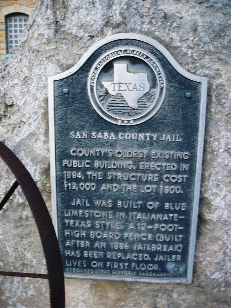
​San Saba County Jail

S
A
N

S
A
B
A

C
O
U
N
T
Y
Marker Text: ​County's oldest existing public building. Erected in 1884, the structure cost $13,000 and lot $500. 
       Jail was built of blue limestone in Italianate Texas style. A 12-foot-high board fence (built after an 1886 jail break) has been replaced. Jailer lived on first floor. (1969) 
Marker No: 4555
Aluminum 14 x 24 Subject Marker
Texas Historic Landmark
Geographic: 31.194546,-98.714081
Location: ​Corner of East Commerce and South Water Streets, San Saba
Picture
Proudly powered by Weebly
  • Greenbrier Cemetery
  • Wilson Chapel Methodist Church
  • Marian Anderson High School
  • Alfred M. Hallmark
  • No 57: Old San Antonio Road
  • Zephyr Cemetery
  • Zephyr Gospel Tabernacle
  • First Baptist Church of Zephyr
  • Military Road
  • Zephyr Presbyterian Church
  • Burkett Pecan Tree
  • Hittson Ranch
  • Callahan City Cemetery
  • Admiral Baptist Church
  • Belle Plaine Cemetery
  • Ross Cemetery
  • The Prew House
  • Brooke Smith
  • Minnie Fisher Cunningham
  • Ebenezer Baptist Church
  • Dodge
  • Site of Andrew Female College
  • Glendale Cemetery
  • Community of Fodice
  • Pegleg Crossing on the San Saba
  • B. T. Brown House
  • German Methodist Church/First Fire Station
  • Providence Church and Cemetery
  • Packsaddle Mountain
  • Homesite of W. F. Heller, Pioneer Farmer
  • The Bosque-Larios Expedition
  • No. 60 Old San Antonio Road
  • No. 56 Old San Antonio Road
  • No. 59 Old San Antonio Road
  • Texas Central Railroad
  • Center City Community
  • Orla
  • Fairview Cemetery
  • Anderson County in the Civil War
  • Leander
  • Oveta Culp Hobby and the Women's Army Corps
  • Jacob Haller House
  • James M. Holt
  • Washington-on-the Brazos
  • Donigan House
  • Fort Worth Stock Yards Entrance
  • Smithfield Baptist Church
  • Elite Cafe
  • Joseph Brooks Home
  • Phair Cemetery
  • Witting School
  • Pioneer Bank Building
  • Whitney Memorial Park
  • Site of Alvarado School, Church and Union Building
  • Two Sheriffs of Mason County
  • New Page
  • New Page
  • New Page
  • New Page
  • New Page
  • New Page
  • New Page
  • New Page