Greenbrier Cemetery
Wilson Chapel Methodist Church
Marian Anderson High School
Alfred M. Hallmark
No 57: Old San Antonio Road
Zephyr Cemetery
Zephyr Gospel Tabernacle
First Baptist Church of Zephyr
Military Road
Zephyr Presbyterian Church
Burkett Pecan Tree
Hittson Ranch
Callahan City Cemetery
Admiral Baptist Church
Belle Plaine Cemetery
Ross Cemetery
The Prew House
Brooke Smith
Minnie Fisher Cunningham
Ebenezer Baptist Church
Dodge
Site of Andrew Female College
Glendale Cemetery
Community of Fodice
Pegleg Crossing on the San Saba
B. T. Brown House
German Methodist Church/First Fire Station
Providence Church and Cemetery
Packsaddle Mountain
Homesite of W. F. Heller, Pioneer Farmer
The Bosque-Larios Expedition
No. 60 Old San Antonio Road
No. 56 Old San Antonio Road
No. 59 Old San Antonio Road
Texas Central Railroad
Center City Community
Orla
Fairview Cemetery
Anderson County in the Civil War
Leander
Oveta Culp Hobby and the Women's Army Corps
Jacob Haller House
James M. Holt
Washington-on-the Brazos
Donigan House
Fort Worth Stock Yards Entrance
Smithfield Baptist Church
Elite Cafe
Joseph Brooks Home
Phair Cemetery
Witting School
Pioneer Bank Building
Whitney Memorial Park
Site of Alvarado School, Church and Union Building
Two Sheriffs of Mason County
New Page
New Page
New Page
New Page
New Page
New Page
New Page
New Page
New Page
TEXAS HISTORICAL MARKERS
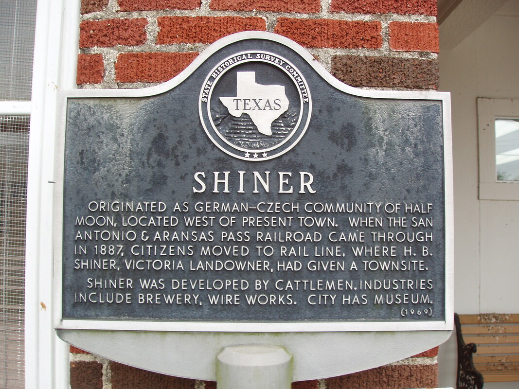
Shiner
Greenbrier Cemetery
Wilson Chapel Methodist Church
Marian Anderson High School
Alfred M. Hallmark
No 57: Old San Antonio Road
Zephyr Cemetery
Zephyr Gospel Tabernacle
First Baptist Church of Zephyr
Military Road
Zephyr Presbyterian Church
Burkett Pecan Tree
Hittson Ranch
Callahan City Cemetery
Admiral Baptist Church
Belle Plaine Cemetery
Ross Cemetery
The Prew House
Brooke Smith
Minnie Fisher Cunningham
Ebenezer Baptist Church
Dodge
Site of Andrew Female College
Glendale Cemetery
Community of Fodice
Pegleg Crossing on the San Saba
B. T. Brown House
German Methodist Church/First Fire Station
Providence Church and Cemetery
Packsaddle Mountain
Homesite of W. F. Heller, Pioneer Farmer
The Bosque-Larios Expedition
No. 60 Old San Antonio Road
No. 56 Old San Antonio Road
No. 59 Old San Antonio Road
Texas Central Railroad
Center City Community
Orla
Fairview Cemetery
Anderson County in the Civil War
Leander
Oveta Culp Hobby and the Women's Army Corps
Jacob Haller House
James M. Holt
Washington-on-the Brazos
Donigan House
Fort Worth Stock Yards Entrance
Smithfield Baptist Church
Elite Cafe
Joseph Brooks Home
Phair Cemetery
Witting School
Pioneer Bank Building
Whitney Memorial Park
Site of Alvarado School, Church and Union Building
Two Sheriffs of Mason County
New Page
New Page
New Page
New Page
New Page
New Page
New Page
New Page
New Page