• Alfred M. Hallmark
  • First Baptist Church of Zephyr
  • Military Road
  • Belle Plaine Cemetery
  • Community of Fodice
  • Providence Church and Cemetery
  • Packsaddle Mountain
  • No. 59 Old San Antonio Road
  • Anderson County in the Civil War
  • Smithfield Baptist Church
  • Phair Cemetery
  • New Page
  • New Page
  • New Page
TEXAS HISTORICAL MARKERS

Site of Nockenut

​W
I
L
S
O
N

C
O
U
N
T
​Y
Marker Text: ​The community of Nockenut began in 1857, when a number of German and Polish immigrants settled in this area. Originally located in Guadalupe County, it became part of Wilson County after a boundary change in 1869. A post office opened in 1858, and by 1890 Nockenut was a thriving village with a population of 80. At its height, the town boasted homes, stores, a school, a church, a wagon yard, a cotton gin, and a cemetery. The origin of the town's name is the subject of several oral history accounts, most of which refer to variations on names of local trees. Nockenut began to decline after the Galveston, Harrisburg and San Antonio Railroad bypassed it in 1906. By the end of the 20th century, the cemetery was the last physical reminder of the community. (2001)
Picture
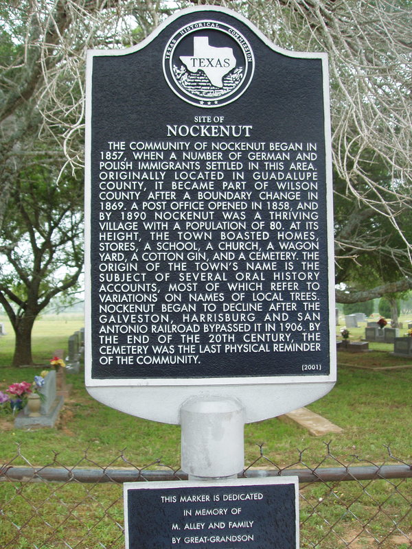
​Additional Plate: This marker is dedicated in memory of M. Alley and family by great-grandson.
Marker No: 12383
Aluminum 18 x 28 Subject Marker
Geographic: 29.2046N, -09.75441W
Location: ​9 miles northeast of Nixon on FM 1681
Proudly powered by Weebly
  • Alfred M. Hallmark
  • First Baptist Church of Zephyr
  • Military Road
  • Belle Plaine Cemetery
  • Community of Fodice
  • Providence Church and Cemetery
  • Packsaddle Mountain
  • No. 59 Old San Antonio Road
  • Anderson County in the Civil War
  • Smithfield Baptist Church
  • Phair Cemetery
  • New Page
  • New Page
  • New Page